
 Sign In With Google
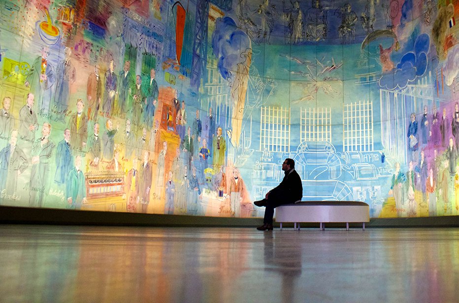
Program Overview
Program Overview
-
Popular Subject Areas
Business, Communications, International Relations & Liberal Arts
-
Location
Rome
-
Host University
The American University of Rome
-
Term
Fall 1 2024
-
Program Dates
Aug 27, 2024 - Dec 13, 2024
-
Program Length
Semester
-
Application Deadline
May 01, 2024
-
Forms and Payment Deadline
May 15, 2024
-
Credit
12 - 16 Credits
-
Eligibility
2.50 Minimum GPA*
-
Cost
$18,350
- This session is closed and is no longer accepting applications.
Study Abroad Program Description
This semester/year program is a great program for studying in Rome! The American University of Rome (AUR) offers courses across a variety of subject areas, including: Archeology, Arts, Business, Communication, History, International Relations, Italian language, Literature, Marketing, Political Science, Social Science, and more.
You will enroll in a total of 12-16 semester credits per semester. Courses will be taught by local and international faculty. Classmates are international students, the majority of whom are North American. Internships are available for Academic Year students only. Courses are taught in English (except for Italian language courses). No Italian language experience is required for this program, although if you have not taken Italian language, you are strongly encouraged to choose language as one of your courses on this program. Some courses may require additional fees. Gap students, 18 years old and older, are also eligible for this program.
Enjoy Flexibility with ISA Flex
We’ve partnered with Arizona State University (ASU) to help you overcome common study abroad challenges by adding an ASU Online course to your ISA program. With more than 2,100 courses to choose from, ISA Flex minimizes academic challenges, like major requirements and limited course options, so you can make the most of your experience abroad. Once you’ve applied, access the Flex form in your ISA Student Portal for more information on how to add this to your program and enroll in the course you need.
*Eligibility
MINIMUM GPA
Students must have a minimum grade point average of 2.50.
MINIMUM ADMISSIONS PREREQUISITES
There is no language prerequisite for this program.
-
You must be at least 18 years old by the program start date.
-
You must submit a course registration agreement. Additional details will be provided after gaining access to the ISA Student Portal.
-
If you have a cumulative GPA below 2.50, you may still be considered for acceptance. You will have to submit one letter of recommendation and a statement of purpose.
What's Included
Comprehensive Advising and Support
Comprehensive Advising and Support
A team of helpful ISA staff members is here to support you through the entire study abroad process, from finding the perfect program through re-entry. The Program Advisors will help you choose your program based on your unique objectives. Once you’ve selected your program, you will work with your Program Manager on the application process as well as pre-departure forms and finances. Your Program Manager will also assist with academics, housing, visas, and city-living/cultural guidance.
In addition to individual advising, you will receive virtual resources to help prepare you for your time abroad. This includes the ISA Student Portal, which houses your program application, pre-departure forms/resources, and the online orientation. The online orientation is a pre-cursor to the on-site orientations and offers city-specific resources about living in your host city, communication, packing, diversity abroad, how to be academically successful, and more.

24-Hour Emergency
24-Hour Emergency
The ISA Health, Safety, and Security team facilitates an in-house on-call system with a U.S.-based employee and manager who are on-call and available in case of emergency 24-7. ISA regular office hours are Monday through Thursday, 7:00am - 7:00pm and Friday, 7:00am - 5:00pm Central Time.
If you are a parent or student needing assistance in an emergency situation outside of the regular office hours, please call the ISA office at 512-480-8522 to access the ISA emergency contact information for that particular week. Students who experience an emergency while abroad will also have access to on-site staff 24-hour emergency assistance.
Comprehensive Health, Safety, and Security Support
Comprehensive Health, Safety, and Security Support
Health, Safety, and Security (HSS) for ISA students is jointly managed by our resident staff and HSS team. This team works to monitor risk at program locations, respond to any crises that may arise, and develop policies to further ensure the health, safety, and security of students abroad with ISA.
Airport Reception
Airport Reception
Ground transportation is provided from the airport as long as you arrive during the ISA designated arrival date and time and at the appropriate airport. Upon acceptance into your program, you will receive the “How to Book Your Flight” form which outlines the specific details for airport reception.
Airport reception is not provided for most Intensive Month or J-Term programs.
Visa Support
Visa Support
Your ISA Program Manager will be available to help you with the visa process for your program country, if applicable. They will provide resources, guidance on necessary steps to obtain your visa, and deliver supporting visa application materials to you as needed.
Tuition at the Host University
Tuition at the Host University
Tuition and administrative fees at the host university are included in the program price. Classes are held at the host university and are taught by local and/or visiting faculty. Some classes will have additional fees that are not included in the program price.
Housing
Housing
Housing is guaranteed and included in the price of all ISA programs, with the exception of Pacific programs, in which housing is offered at an additional cost. Accommodation options will vary according to program site and session. For more details about ISA's housing options and applicable security deposits, please refer to the housing tab for your program of interest.
Bridging Cultures Orientation
Bridging Cultures Orientation
The Bridging Cultures Orientation will be delivered to you in the first few days of your time abroad. It is designed to prepare you for a successful, positive, and rewarding experience that will influence the rest of your life. This is accomplished through introducing you to your host city’s culture and infrastructure as well as through goal setting, intercultural awareness, diversity and professional development activities.
Full-Time Resident Staff
Full-Time Resident Staff
The full-time resident staff is available to assist you with all aspects of your experience abroad. The resident staff provides support during official course registration and arranges the Bridging Cultures Program orientation, excursions, weekly meetings, cultural activities, and much more. Staff members are trained to ensure the well-being of each program participant and are dedicated to facilitating a positive and meaningful study abroad experience.
On-Site ISA Offices
On-Site ISA Offices
Most program locations have an on-site ISA office within the program city. The on-site offices provide you with an additional comfortable space in the city and serve as a common meeting place and resource center.
Internet Access
Internet Access
As an ISA student, you will enjoy free internet access at ISA on-site offices, computer labs at the host university, and/or your ISA housing.
ISA Discovery Model
ISA Discovery Model
ISA programs facilitate learning and development through co-curricular activities. We rely on host universities to provide quality instruction in the classroom, but ISA is the main facilitator of learning outside of the classroom. Efforts to promote student learning are shaped by a teaching and learning framework we call the ISA Discovery Model.
According to this model, student learning and development is organized into five areas of discovery: 1. Intercultural, 2. Historical, 3. Sociopolitical, 4. Professional and 5. Environmental
Throughout the duration of your ISA program, we provide you with the opportunity to pursue these five areas of discovery through the Bridging Cultures Orientation, excursions, cultural activities, and references to non-ISA sponsored events and opportunities.
Excursions
Excursions
Organized excursions are included with each program to complement the academic component of your abroad experience. These complementary experiences are designed to engage student learning outside of the classroom in the five areas of the Discovery Model. Transportation and guided tours are included, as well as hotel accommodations and breakfast during multi-day excursions. Additional optional excursions may be offered during each program that are not included in the program cost.
Excursions are not included for Intensive Month, J-Term, and some summer sessions.
Cultural Activities
Cultural Activities
The ISA program staff develops unique cultural activities custom-designed to invite you to experience the local color of your host city, while learning about the history and culture of your new surroundings. Speaking the native language with locals, tasting the regional cuisine, and partaking in the native traditions are only a few of the ways these cultural activities lead to full appreciation of the program city.
Insurance
Insurance
A Blanket Accident and Sickness Policy is included in the program and covers you during the official on-site period of the program. This is not an optional benefit; every ISA participant will be covered by this policy. A full description of coverage can be found on the ISA website.
We recommend that you maintain comprehensive health insurance while abroad. This is particularly important if you have any pre-existing conditions but is also beneficial if you have an injury or illness while abroad and require further treatment upon your return home. Please be sure to consult with your current insurance provider to confirm coverage policies while traveling abroad.
Official Transcript from the Host University
Official Transcript from the Host University
Upon completion of the ISA program, your host university will issue an official transcript with all coursework taken abroad. ISA's Academic Records Department will process and forward the official transcript to the appropriate office at your home university, and a photocopy will be sent to your permanent home address for your records. ISA will provide a cover letter to accompany the transcript with important academic information, including the host university's grading system and recommended U.S. letter grade equivalencies, translated course titles, and credit conversion recommendations.
Professional Development Toolbox
Professional Development Toolbox
The Professional Development Toolbox, available in the online orientation section of the student portal, will help you identify the skills and key competencies you have developed through your personal, academic, and cultural experiences. This toolbox helps you to articulate the transferable skills developed through study abroad in a way that shows potential employers or post-graduate universities the benefits our you will provide them as a direct result of your experience abroad.
Scholarship Opportunities
Scholarship Opportunities
As an ISA participant, you will have the opportunity to apply for scholarships or grants that can be applied directly to assist with your study abroad program. ISA offers over $1,000,000 in scholarships and grants each year. To see what opportunities are available, please visit the Support & Funding page.
Academics
Credits
Credits
12 - 16
Recommended U.S. Semester Credits
12 - 16
Recommended U.S. Quarter Units
18 - 24
Academic Information
PROGRAM STRUCTURE
- You will take 12 to 16 credits during this session. Most classes meet Monday - Thursday.
COURSE SELECTION
- Courses and course hours of instruction are subject to change.
- Eligibility for courses may be subject to a placement exam and/or prerequisites.
- Course availability is based on enrollment numbers.
- You should seek pre-approval for alternate courses in the event of class cancellations.
SYLLABI
- Requests for sample syllabi can be made to the Italy Program Manager.
COURSE LEVEL RECOMMENDATIONS
- ISA offers course level recommendations for the courses listed below. Please note that the course level recommendations are based on the host university course level recommendations and course codes and are only recommendations. Course numbers generally adhere to the following guidelines:
- 100-199 Lower-level introductory courses with no prerequisites
- 200-299 Lower-level courses with one or more prerequisites
- 300-399 Upper-level courses with one or more prerequisites
- 400-499 Upper-level advanced courses with two or more prerequisites and/or senior standing.
- These ISA recommendations are intended to facilitate the determination of course equivalencies by advisers and credential evaluators at participants' U.S. home institutions.
COURSE FEES
- Some courses may require additional fees which are to be paid directly to the host university. Lab fees, when applicable, are about $75. Field trip fees can vary greatly. Refer to the course description for applicable fees.
TRANSCRIPTS
- Upon program completion, you will receive a transcript issued directly from the American University of Rome (AUR). The transcript will reflect U.S. semester credits for all courses taken.
COURSE CREDIT
- Credits earned vary according to the policies of your home institutions.
- According to ISA policy and possible visa requirements, you must maintain full-time enrollment status, as determined by your home and host institution, for the duration of the program.
- Credit transfer is ultimately determined by your home university.
LANGUAGE PLACEMENT
- Enrollment in Italian courses is determined by the results of a language placement exam administered by the host university. Please note that your performance on the placement exam may not reflect the number of semesters of language instruction you've already completed at your home university.
- We strongly suggest that if you are trying to place into any level of language beyond true beginning, to prepare for the language placement exam by reviewing previous coursework.
LANGUAGE RECOMMENDATION
- If you have not completed a college semester of Italian language or the equivalent, you are strongly encouraged to take an Italian language course while on this program.
- Italian courses are offered from the Beginner to Advanced level.
Please Note:
The courses below reflect the most current list of courses released by the host university. Please refer to this list when completing your pre-registration form. Also note that courses are always subject to change.
Courses
select allclear all
Course Disclaimer
- Availability of courses is based on enrollment numbers. All students should seek pre-approval for alternate courses in the event of last minute class cancellations
Support & Funding
ISA is here to support you when it comes to navigating identity questions related to traveling abroad, providing resources and information for your accessibility needs, and identifying funding for your program abroad.
SUPPORT TEAM
Our U.S. staff is available to support you though every stage of your study abroad journey. Please reach out with any questions about ISA programs or life on-site to your country-specific Program Manager.
Our on-site staff are there for you as soon as you arrive in country and will support you throughout your time abroad.
U.S. Team

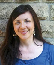
Sidney Stamm
Program Manager, England & Italy
Born and raised in Dallas, Texas, Sidney graduated from Tulane University in New Orleans with a Bachelor of Arts in Communications. Sidney's adventures abroad began when she studied in Buenos Aires, Argentina in high school getting to practice Spanish with her host family. Having discovered her love for new cultures, she interned abroad (with ISA!) in Madrid, Spain at a PR agency/fashion showroom. Upon visiting Berlin after her internship, she met some lifelong friends in Germany and began teaching herself German. She firmly believes in the importance of international exchange and finds it to be an incredible opportunity to open one's mind to previously unknown career paths and creative passions. Sidney enjoys writing, reading, and is a self-declared expert at charades.
Jessie Llerena
Region & Account Manager, Europe
Born and raised in New Jersey, Jessie graduated from Rutgers University with a B.A in Psychology. Her love for traveling started at a young age from visiting family back home in Ecuador. She is passionate about helping people and delivering high quality care. In her free time, she likes to spend time with family and friends, play with her dog, Cash, work out, and travel (of course!). Jessie finds that studying abroad is important to learn about different cultures, as it creates lasting relationships and memories. She is excited to be a part of the ISA team and to support students through their studies overseas
ROME TEAM
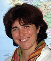
Mattea Di Fabio
Resident Director, Italy
Mattea Di Fabio
Resident Director
A lifelong resident of Rome, Mattea Di Fabio is the foundation of our ISA Rome staff. She has been with ISA since 2004 and is the ISA Rome Resident Director. Mattea graduated from the University of Rome (La Sapienza) with a bachelor's degree in Humanistic and Historical Studies. She has traveled extensively throughout Europe, and her background includes extensive work with Italian high school students studying abroad in England, Ireland, Austria, France, and Malta. She also has experience in Italian primary and secondary schools, where she worked as a teaching consultant helping teachers develop a more critical awareness with their pedagogy and lesson planning.

Mara Cecili
Student Services, Italy
Mara Cecili
Student Services
Mara Cecili was born in Rome, where she is currently living. She graduated with a Bachelor's degree in Modern Languages (English and Spanish) at the Rome University La Sapienza, where she is currently finishing the last year of her Master's degree. She has traveled throughout Europe (England, Ireland, Spain etc.) and has had the opportunity to deepen her knowledge of art and architecture – both of which are her passions since her years at art school. Mara looks forward to working with ISA Rome students to make sure their stay in her home city is unforgettable!
Vera Contu
Assistant Resident Director/Housing Coordinator, Italy
Vera Contu
Assistant Resident Director/Housing Coordinator
Vera was born in Rome and has lived there her entire life. She graduated from La Sapienza University in Rome with bachelor's degree in Philosophy. She has qualification certificates in Co-operative Management and Web Design from the Lazio Region in Italy. She is well-traveled throughout Europe, and both North and South America. Vera has worked at summer camps as an Activity Manager with Italian high school students during their time in England and Ireland. She also has experience working with Italian primary school students as a teaching consultant where she assisted teachers as they developed informational computer projects. She enjoys volunteering with the World Wildlife Fund (WWF) Initiatives and has collaborated with them in Greece, Sardinia and Tunisia.
Identity Resources
Accessibility & Accommodations
With our wide portfolio of program types and locations, we’re confident there is a suitable, accessible program for each student.
Securing accommodations abroad can take time, so we ask that those with requests inform ISA early in the advising process. We recommend reaching out to your Program Manager or our Accessibility Team (accessibilityteam@worldstrides.com) to discuss your accessibility needs or accommodations abroad.
Destination Information
Our diversity pages for each ISA destination include information on Indigenous communities, languages, race and ethnicity, religion, LGBTQIA+, and disability access. We hope it will help when reflecting upon and contextualizing intersectionality in your host community.
Identity Blog
ISA offers students the opportunity to blog about their experiences abroad from their own diverse perspectives. These posts can be found on the ISA Student Blog, and interested students should email diversity@studiesabroad.com for more information.
Funding
All students should have the opportunity to study abroad. To help make this a reality, ISA offers a variety of scholarships to help cover your study abroad costs. To learn more about our scholarship opportunities, check out our scholarships & grants page!
If you receive financial aid from your home university, you can likely use those funds for study abroad, as well. Speak with your home university’s financial aid office to learn about your options. Check out steps for using financial aid.
Questions about scholarships and funding? Email us at higheredfinaid@worldstrides.org
Housing
ISA in Rome includes comfortable housing in shared, fully-furnished accommodations conveniently located in well-established neighborhoods in close proximity to the universities. A $300 refundable security deposit will be charged to students living in ISA arranged housing. ISA may retain some, or all, of this deposit in the case of damage to property or if utility usage exceeds the allotted monthly amount.
We strive to match your housing preferences with our available accommodations; however, housing preference requests cannot be guaranteed.
Apartment
For ISA programs at The American University of Rome, students will stay in shared, fully-furnished student apartments. There are generally only one or two student apartment units per building, and neighboring residents are typically middle-class Italian families who own their apartment. Most ISA apartments have 2-3 bedrooms, a lounge/living room, kitchen and bathroom(s). Bedrooms are typically double-occupancy. Each apartment includes one single bed per student with bed linens. A computer that is connected to the internet via a cable modem is to be shared by all occupants and wifi is provided in all apartments. All apartment units include a washing machine.
Independent Housing
You may elect to secure housing independently. If you select this option, you will receive a discount equal to the housing portion of the program price.
Housing is not included during the winter break and/or the break between the fall and spring semesters for those students completing the full academic year. Housing is also not included between the academic semesters. Please contact your ISA Program Manager if you would like to add ISA housing for an additional cost during these periods.
Excursions
THERE’S MORE TO DISCOVER WITH ISA
ISA excursions allow you to explore the diverse, distinct, and gorgeous landscape of Italy that you may not be able to visit on your own. While abroad, you will have the chance to go on 2-3 excursions. The destinations shown below are a sample of some of the possibilities, which are finalized in the time leading up to the start of your program.

Florence & the Chianti Region
Explore the "Cradle of the Renaissance," taking guided tours of art museums, views of the Ponte Vecchio, and wandering through the central square to marvel at Brunelleschi's towering Duomo and Ghiberti's golden Gates of Paradise. Spend the afternoon walking through the bustling San Lorenzo market where you can find everything from pasta and vegetables to purses, belts, and shoes. Continue on to the Chianti region and tour a vineyard, sampling world famous Italian wines. Enjoy the picturesque views of the valleys and surrounding hillsides that stretch out into the distance.
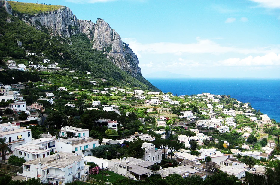
Sorrento, Capri & Pompeii
Discover Southern Italy's treasures in the Bay of Naples! First, you’ll head to Sorrento for an overnight stay, famous for its limoncello liqueur and astounding view of Mt. Vesuvius. Then, you’ll spend the day on the sunny island of Capri. Once on the island, you can tour the famous Blue Grotto, Monte Solaro, and the quaint village of Anacapri. Finally, you’ll visit the ancient city of Pompeii, infamously buried in ash by Mt. Vesuvius. Everything here is meticulously preserved by the cataclysmic eruption of Mt. Vesuvius in 79 AD.
Cultural Activities in Rome
The ISA on-site team encourages you to explore the city and culture of Rome. The team facilitates this by offering a robust calendar of events that showcases what makes Rome special.
These activities vary each term, and previous offerings have included cooking lessons, guided tours of the Capitoline Museums, a visit to a gelato factory, guided tours of the Colosseum, Roman Forum, and the Palatine Hill, and a walking tour of the famous fountains in the city.